All posts tagged: GIS

Bakersfield Site Analysis

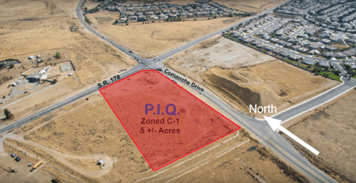
In January 2016, I was given the opportunity by Mr. Frank Tripicchio to work on a site analysis project on a property in Bakersfield, CA. The objective was to create recommendations on best uses for the property through demographic and economic analysis. To help me with this report, I brought on Oliver Yang, who worked with PKF Hospitality Consulting. The Project The site is located on the Southwestern corner of the intersection between Highway 178 and Comanche Dr., about 5 miles away from downtown Bakersfield. It is an undeveloped, five-acre parcel with two residential communities in the immediate area. I conducted spatial analysis with data from the U.S. Census Bureau and the City of Bakersfield to visualize the current building and zoning conditions in the area as well as the demographic distributions. We assessed community needs by looking at current services, businesses, and retail in the area and found a gap in the supply. As the site is fairly remote, there is a lack of businesses servicing the area. There are around 3000 residential rooftops in the surrounding …

WLM Financial Marketing and Branding

During September 2015 to January 2016, I worked as a Marketing Coordinator/Analyst for the real-estate broker WLM Financial. Based in Inglewood, CA, the company focused on providing first-time home buyers with financial advice and loans needed to purchase their home. Using my knowledge of GIS and demographics, I identified the locations of their target markets. I proposed ten cities in the Los Angeles Metropolitan Area that they can look to expand marketing operations into. On the broker side of business operations, I looked at home sales data, mortgage data, and property prices to locate other states that WLM Financial can look to apply for broker licenses. After getting to know their operations, targets and goals better, I created a marketing and a branding plan for the company. In terms of brand building, I used their current website and Facebook page as points of interest and set goals to be reached by July 2016 and July 2017. I created a social media schedule for them to post select content and to generate more reach and views to …

Learning and Growing! Internship and Coursera Specialization!

Last week, I started my internship with WLM Financial – a real-estate brokerage. With my interest in urban planning and development and my background in the social sciences, it appears to be a good fit to work as their Marketing Intern. I was quickly integrated into the marketing team and I am happy to say that the owners have been very trusting and gave me a great opportunity to learn. They have taught me a great deal in the past week about mortgages and real-estate. They are always open to questions and really took me under their wings. I look forward to learning more about the real-estate industry and about business development. Though I am only an intern, my opinions were valued and contributed to the direction the company is taking. Using my skills with ArcGIS, I took the initiative located our target audiences. I integrated demographic data with geospatial data from the U.S. Census Bureau to reveal locations where our target audience might be located. I was quickly able to locate ten cities in …

Glendale Historic Downtown Redesign

Glendale Historic Downtown Redesign was an urban redevelopment and design project for the city of Glendale, Arizona. With an aging population and a struggling economy, Glendale has been trying to revitalize its downtown core for years (culminating in the hosting of Superbowl XLIX). This project was an attempt to address these issues by developing a plan, through development and policy, that will benefit parts of the historic downtown. Under the guidance of Professor Emily Talen and Dr. Michael Powe, we followed the Preservation Green Lab‘s methodology in examining neighborhood physical characteristics through a combined measure of building age, building diversity, and lot size. Using grid overlay analysis, we incorporated demographic data from the U.S. Census Bureau and identified and presented a neighborhood that had the greatest potential for revitalization through existing policy and design. In addition, we conducted field observations of the study area. Some of the issues we found was the lack of consistent frontage which reduced the physical attractiveness of the area. There was a lack of mix-used buildings, with would serve to bring residents and businesses together. In addition, …